
The stretch of beautiful weather that started last week continues across Pennsylvania, New York, and New Jersey. Expect partly to mostly sunny skies with highs in the mid to upper 70s today, while coastal areas may stay a few degrees cooler due to an east wind. Radars remain quiet and are expected to stay that way for the next few days. Tonight will be clear and cool, with lows ranging from the 40s inland to the 50s and near 60 closer to the coast.
High pressure dominates the region from the Great Lakes to Atlantic Canada, keeping conditions calm. The system will slowly shift offshore by Wednesday, while a cold front from the Plains and Great Lakes moves east but will be delayed by the strong high. Rain chances will hold off until late Thursday night or Friday.
Related posts


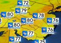
Labor Day Monday will wrap up the holiday weekend with plenty of sunshine and highs in the mid-70s to near 80°F inland, while south- and east-facing shorelines stay in the low 70s.
Dew points remain comfortable in the 50s through Tuesday, with a slight uptick by Wednesday. Expect partly to mostly sunny skies both days, with highs in the mid-70s to around 80°F inland. By Wednesday night, patchy fog and low clouds could develop as the air mass becomes more stagnant.
By Thursday, humidity rises slightly, and showers or thunderstorms may arrive late at night or on Friday as the front finally pushes closer to the East Coast.
This article has been carefully fact-checked by our editorial team to ensure accuracy and eliminate any misleading information. We are committed to maintaining the highest standards of integrity in our content.


