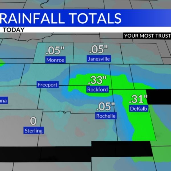
Skies have stayed dry and temperatures warmed after early-morning rain moved through southern Wisconsin and northern Illinois. While not all areas saw rainfall, spots with the heaviest showers collected just under half an inch.
Clearing Skies and Warmer Afternoons
This Article Includes
By mid to late morning, clouds cleared quickly, leading to partly cloudy skies throughout the afternoon. With added sunshine, temperatures climbed into the mid-to-upper 70s, and a few locations even touched 80°F — a welcome warm-up after several cooler days.

Cold Front Moves Through
A lake-enhanced cold front passed through the Stateline Thursday evening, marked by a shift in winds to the northeast. A few showers and isolated thunderstorms formed along the boundary, mostly south of I-80. With the front now south of the area, rain chances remain minimal for the evening. As skies clear, temperatures will dip into the low 50s, and patchy fog may develop early Friday morning.
Weekend Outlook
High pressure sliding through the Great Lakes will keep the weekend mostly dry. However, a weak upper-level disturbance moving across Wisconsin late Friday may spark isolated sprinkles or light showers. Most precipitation chances remain to the west and northwest.
Friday night into Saturday could bring a few scattered showers, but overall, dry conditions are expected to dominate through Labor Day.
Labor Day Weather
By Sunday and Monday, temperatures will warm near 80°F, aligning closer to seasonal averages — setting up a quiet and comfortable start to September.
This article has been carefully fact-checked by our editorial team to ensure accuracy and eliminate any misleading information. We are committed to maintaining the highest standards of integrity in our content.


