A stationary boundary just east of the Tennessee River is keeping showers away from West Tennessee today, but rain chances will increase Tuesday as a low-pressure system tied to a weak front moves through the region. The system could bring scattered showers and a few weak storms, with some rain lingering into Wednesday. Another front arrives Thursday, but it currently looks mostly dry.
This Week’s Forecast
This Article Includes
After a pleasant Labor Day weekend, the nice weather continues today, but changes are on the way. Early Monday morning showers near the Tennessee River quickly moved east, leaving the area dry. The showers formed along a stationary boundary linked to a low-pressure system in east Kansas, which will track into West Tennessee on Tuesday.


Clouds will increase overnight as the system approaches, with calm winds and overnight lows in the mid-60s.
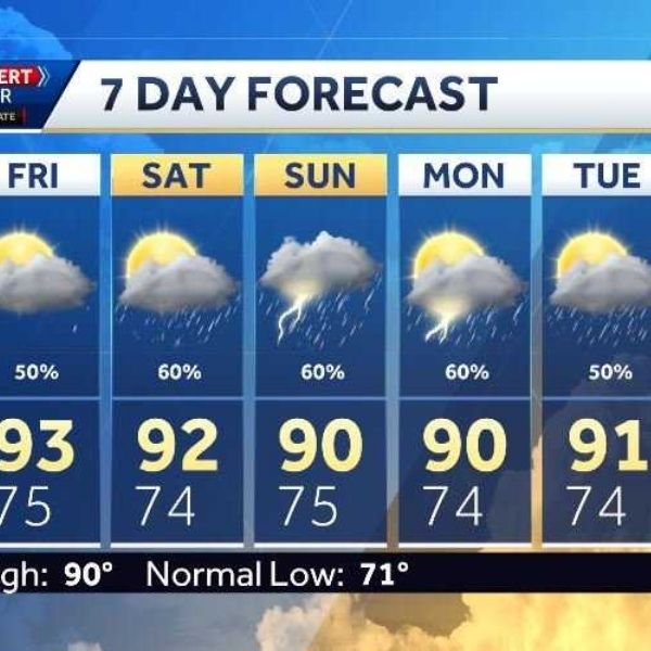
Tuesday: Best Chance for Rain 🌦️
-
Conditions: Mostly cloudy and more humid
-
Highs: Mid-80s
-
Rain Chances: 60%
-
Storms: A few weak thunderstorms possible, but no severe weather expected
-
Tuesday Night Lows: Mid-60s
Wednesday: Lingering Showers 🌤️
Some scattered showers may persist along the trailing front, mainly south of Jackson in the afternoon and evening.
-
Rain Chances: 30%
-
Highs: Mid to upper 80s
-
Skies: Partly cloudy
-
Winds: Shift from southwest to northwest
-
Overnight Lows: Mid-60s
Thursday: Another Front Moves In 🌬️
A new front will approach and stall across the Mid-South, but for now, it appears to be a mostly dry system.
-
Skies: Partly cloudy
-
Highs: Mid-80s
-
Rain Chances: 20% (may increase later)
-
Overnight Lows: Upper 50s
Friday: Warmer & Mostly Dry ☀️
As the front lifts north, temperatures will climb into the low 90s. A few isolated showers are possible, but chances remain low at 20%.
-
Conditions: Partly cloudy
-
Highs: Low 90s
-
Friday Night Lows: Around 60°F — perfect for Friday Night Football
Weekend Outlook 🌤️
The first weekend of September looks mild and comfortable for West Tennessee.
-
Saturday: 20% chance of showers, partly cloudy, lows in the low 50s
-
Sunday: 10% chance of showers, sunnier skies, lows in the mid-50s
-
Winds: North to northeast
-
Overall: A pleasant weekend — ideal for outdoor plans before hotter, humid weather returns later this season.


